Saturday, December 31, 2016

Streaky Bay to Elliston

December 24 to December 31
  
Murphy's Haystack Granite Formations
Christmas Eve Saturday reached 380C by midday, so by the time Streaky Bay regained power at 1pm (after a 24 hour power outage from the previous day’s storm), we happily checked in to the caravan park and started our air conditioner in the motorhome. We also were able to extend our stay in the caravan park by a day, so we were staying for three nights, until Tuesday.
Although only a small seaside town of around 1000 residents, with one caravan park and one pub, it has a long history dating back to 1839 when explorer Edward John Eyre established a camp. Farming commenced in the 1850’s and an oyster factory in the 1870’s. A surprising number of historic buildings are restored and still in use throughout the town.
We checked with the pub to see if they were open on Christmas Day for lunch or dinner, but alas they weren’t after a large booking cancelled recently.
More Murphy's Haystack Granite Formations
Christmas Day Sunday was nice and low key, we walked the bay trail in the morning before it got too hot, and I went for a paddle on my wave ski in the bay to keep cool, and to learn the finer skills of blue swimmer crab hunting. I say hunting because one method to catch them is to arm yourself with a hooked, rake like implement (and/or a landing type net) and walk around the shallows (knee to thigh deep) of the bay watching for them to swim by and bury themselves in the sand. You then “rake” them up to capture them and put the legal ones in a bucket (which your accomplice carries, or floats on a kayak you tow around). All very primitive. Three teenagers let me help them by spotting, and with a bit of practice you can spot them already buried as well as swimming around.
Venus Bay Coastline looking South
The afternoon was again spent hiding away from the 380C in the air con, and watching storms brew to the north and east of us. The cyclone that went through Broome was bringing a lot of instability through the centre of Australia and down to South Australia.  We received some strong wind gusts and rain but most of the weather hit east of us and towards Adelaide. Over the next two days flooding rain and power outages greatly affected the state to our east.
Venus Bay Township on the edge of the cliffs
Monday the rain set in and the wind blew. We did manage a coastal walk into town but still got wet.
Tuesday was much of the same, and even though we checked out of the caravan park, we stayed around town and decided that we would overnight at the low cost ($10) RV area in town. We were surprised that we were on our own in the camp area, as the caravan park was full. It was also a bit protected from the wind which was nice.
Venus Bay cliffs, township and bay in the background
Wednesday we departed Streaky Bay and drove south to Murphy’s Haystacks. This is a grouping of interesting, protruding granite formations on a private farm that have been weathered by wind and rain. The owner made the area available for tourists with a walking track around the formations.
Further southeast we passed through Port Kenny before stopping overnight at a secluded rest stop not far out of town.
Elliston bay and Jetty
Thursday we drove 10km further to Venus Bay. This small fishing village is at the mouth of the bay of the same name, and is currently full for the holiday season. One of the features of this village is the South Head Walking Trail, a 4km trail around the cliff edge of the ocean and bay. This may be the most spectacular cliff walk we have done. The photos just don’t do justice to the overall experience of the headland and landscape.
Sculptures on the Elliston Coastal Cliffs
We spent rest of the day walking the jetty and town, I was keen to go fishing but with 30+km/h winds (and for the foreseeable future) I had to give it a miss. We returned to the rest area out of town after a surprisingly enjoyable day. Visit Venus Bay if you pass this way, a hidden gem.
Friday we continued southeast to Elliston. This small village is situated in a small bay which again has spectacular cliffs lining the ocean coastline, and (fairly) protected waters within the bay. We decided to stop here for the New Year’s weekend, one night in their caravan park and one night at their RV Friendly camp spot at the golf club. The golf club is high on a hill overlooking the bay and town, and they only prepare the course for play in the winter months, so it unused for the rest of the year.
Elliston Coastline, and township on the near side of the bay
We caught up on washing at the caravan park on Friday, as well as walked the bay beach next to the jetty. The jetty is currently closed due to damage caused by the wild storms in September (when the whole of South Australia lost power). The waves were half way up the light poles along the jetty (check the photo and try to imagine it). I went for a bike ride along the southern cliff trail to scope it out, it’s not a loop walk so I wanted to select a section to walk with Leah on Saturday.
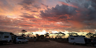
New Year's Eve sunset, not a bad camp spot, Elliston
Saturday we drove the northern tourist drive along the cliffs, a spectacular 10km dirt road with numerous lookouts, and interesting sculpture installations at the lookouts (the one's that survived the September storm). We also walked the “selected” southern cliff walk. We were as astounded with the cliffs as we were in Venus Bay. It seems these cliff formations keep going for hundreds of kilometres south of Streaky Bay (probably an extension of the Bunda Cliff formations in the Bight?). Saturday night, New Year’s Eve, we had the RV park at the golf club to ourselves, so we toasted the new year (early) with the sunset (see photo) as our company.
Sunday we continued the drive southeast, to explore more awesome cliffs and coastline. 

Friday, December 23, 2016

Norseman to Streaky Bay

December 17 to December 24
  
We left Norseman last Saturday to cross the Nullarbor, 1200 kilometres until we make the next town, Ceduna. There are plenty of camping and stopping options along the highway, roadhouses every couple of hundred kilometres, but no fresh water until Ceduna. We carry about 110 litres, enough to last us at least four days. We decided to take four days (all things being equal) and travel around 300km each day.
Sunset over the Roe Plains, WA
We noticed early in the drive that the traffic volume was lower than we expected, probably less than we encountered in the remote north of WA. Given the Eyre Highway is the main link to the east I thought it would be “busier”. You are warned to watch for cyclists in the brochures, something I hadn’t thought of. Apparently it’s a “thing” for cyclists to do the crossing. We passed our first cyclist on the first morning, as well as walkers pushing carts (containing their travel needs), and two runners with a support vehicle.
The countryside leaving Norseman was hilly and wooded, as we drove along the Frazer Range and then the bushy plains of the Nuytsland Nature Reserve. We stopped at Balladonia Roadhouse for lunch, and visited their museum. The Skylab satellite came back to earth in this area in the 1970’s, and they have numerous pieces of the wreckage, as well as history of the early explorers and camel train drivers who frequented this route. Not far out of Balladonia we reached the longest straight piece of road in Australia, 145km without a bend or even a kink.
Start of the Bunda Cliffs, Great Australian Bight
Saturday night we stopped at the Baxter Rest Area, near the other end of the “straight”.
The next morning the landscape stayed bushy and a bit boring for another 200km until we reached the Madura Pass. It is here you drive down from the high plains to lower Roe Plains. The road then tracks the Hampton Tablelands, an escarpment that remains within 10 kilometres on your left for the next 200 kilometres. We stopped overnight about half way along the Roe Plains, and witnessed a spectacular sunset on our last night in Western Australia.
Bunda Cliffs
Day Three started with a short 100km drive to reach the WA/SA border. We left early as the time difference was 2½ hours (ahead) as we entered SA. Here the escarpment crosses our path as it heads towards the sea, and we drive back up the Hampton Tablelands.
It’s from here the drive gets spectacular. For the next 150km you drive along the top of the Bunda Cliffs, where Australia drops vertically off into the Great Australian Bight. There are a number of outlooks, with the cliffs only a couple of hundred metres from the highway, to take in the spectacular coastline. We visited every one, each having a slightly different perspective of the cliffs and coastline. Although the weather wasn’t ideal, a strong southerly blowing sea mist onto the cliffs, the views were still mind blowing.
More Bunda Cliffs
We stopped overnight at the eastern end of the Bunda Cliffs. You can stay overnight at the lookouts, but the southerly winds were too strong so we found a spot well off the highway on the northern side.
Day four (Tuesday) the landscape quickly changed when we reached the “town” of Nullarbor. We drove into the true meaning of the Nullarbor name (no trees), the plains were only low scrub and sparse grass. This lasted for only a 100km or so before becoming rolling hills and bushland. We detoured to Fowlers Bay, an early settlement where whaling occurred from around 1840. We spent most of the day there before deciding not to stay (still only 200C and windy) and headed back to the highway and stop about 35km out of Ceduna.
Fowlers Bay, massive sand dunes behind the houses
We had mixed expectations for Ceduna, with some friends liking it and others not, but we were just ready for some civilisation and the need to catch up on some washing. We stayed “in town” at the Foreshore Caravan Park, opposite the bay and jetty. For a remote town, fuel and food was surprisingly well priced. There is a large grain port for the area’s predominant wheat production, and more recently oysters have become a major produce, now stretching throughout the pristine bays from Coffin Bay, some 300km south east. We bought some for lunch on the day we arrived, thumbs up for civilization!
Ceduna Foreshore
We stayed two nights and enjoyed the foreshore and the long coastal walk trail to Pinky Point at Thevenard (the grain shipping port). We had a couple of great weather days, and left with our own good impression of the town.
Friday we drove south-east, tracking the coastline along Laura Bay to Smoky Bay. The maximum for Friday was predicted to be 380C, and we had 410C according to the Iveco as we reached Smoky Bay at 11am! The next three days (including Christmas Day) have the same predicted maximums, so we are keeping as close to the water as we can.
After a walk out along the jetty we planned to buy some Smoky Bay oysters for lunch. There is some fifteen producers operating in the bay, but only one was open on the Friday before Christmas. And they had no oysters! The owner “should be back in 5 minutes” with some fresh from the lease, but he was nowhere to be seen.
We drove to Haslam, a small fishing village at the northern end of Streaky Bay. They have a low cost camp ($5 donation) where you can stay 100 metres from the beach. As we drove in, the temperature dropped 50C in the 3km from the highway to the beach. A couple of fellow campers were fishing for squid from the jetty, but had caught one between them in three days. I decided not to bake in the sun with those odds. The shade and cool sea breeze was our haven for the afternoon.
Streaky Bay, shady park in 340C 
A storm brewed to the north of us in the early afternoon but passed us by, then we heard on the news Ceduna copped it (four hours after we left) with 110km/h winds. The whole western coastline of the Eyre Peninsula (some 500km, including Haslam) lost power around 1pm. It was not restored until 1pm the next day. I felt sorry for the home owners who had stocked up on food for Christmas.

Saturday we continued around the bay another 40km to the township of Streaky Bay. They have a low cost camping area in town, but given we had two more days of heat wave to endure, we tried our luck at the caravan park. They fortunately had a powered site available for two nights (not that they had power until after lunch), so we treated ourselves the luxury of power for our air conditioner for the Christmas Weekend. 

Friday, December 16, 2016

Esperance to Kalgoorlie to Norseman

Esperance to Kalgoorlie to Norseman
December 11 to December 17

Granite outcrops at Twilight Beach
Sunday in Esperance was hot, 360C until about 3pm when a cool change came through. We stayed around the beach and in the shopping centre stocking up. The coastline from Cosy Corner right through to Esperance (some 500+kms) has interesting island formations just off the coast. They are mostly granite outcrops, most have little soil so no vegetation, and many are gently sloped allowing swell to often wash up and over them. Certainly not what you see on the east coast. The outcrops in the photo are off one of Esperance’s best known beaches, Twilight Beach, voted Australia’s best beach in 2006.
Australia's longest running brothel, Hay Street Kalgoorlie
The Christmas parade and celebrations in Esperance were pretty low key. We left before the parade as it was an evening program. We drove to Gibson, only 30km north of Esperance for the night. The local hotel, The Gibson Soak, allow self-contained RV’s to park for free overnight in their very extensive parking area.
Monday we drove to Norseman, 200km from Esperance and the starting point of the Nullarbor Drive, the Eyre Highway. We weren’t ready for the big drive east yet, we still wanted to visit Kalgoorlie and Coolgardie, another 200km north. The weather was awful. After Sunday’s maximum in Norseman of 400C, Monday was 200C, wind and 50mm of rain, nearly half their annual rainfall. We decided to stay there overnight and “hide” from the weather as it was due to pass overnight. We drove to the lookout, but the visibility was about 1km. Norseman is an RV friendly town and had a great open grassy (not boggy) area to park overnight.
Click on the picture to see the guy washing the truck
to get an idea of the size
Tuesday we headed to Boulder/Kalgoorlie. This is a twin town that developed in the late 1800’s with the gold rush. A fun fact, the population of Boulder/Kalgoorlie in 1901 was 30,000, the population today is about 30,000.
We were keen to visit the “Super Pit” open cut gold mine, the largest open cut pit in the Southern Hemisphere. We were fortunate that the rain stopped, as they had cancelled Monday’s tour (and the mine’s operation) due to the rain. We booked on the Wednesday tour and walked around Kalgoorlie, visiting numerous historic and interesting places including Australia’s longest running brothel (for research reasons only, for the blog).
The Super Pit, the massive trucks look pretty small at the bottom
We also visited Mount Charlotte, a lookout and water storage tank. I was unaware of the engineering history of the “Golden Pipeline”, the world’s longest fresh water pipeline, some 550km. Due to the desperately arid conditions, a dam near Perth was build and a pipeline and pumping system was laid and commissioned in 1903. It is one of the three historic engineering feats recognised, along with the Snowy River Scheme and Sydney Harbour Bridge. Kalgoorlie are also RV friendly, and offer free overnight parking at Centennial Park only a kilometre from the town centre.
Actual Toyota Hilux, run over to demonstrate
what a dump truck can do
Wednesday we did the super pit tour, a tour well worth doing. We were taken onto the mine site, into the super pit, down about 100 metres below ground level (the pit is some 600 metres deep all up), and around the massive equipment and gold processing plant. The tour guide has worked at the mine for many years so was very informative. Hopefully some of the photos give you a feeling for the size of this operation, 30 trucks at any one time carrying 250 tonnes of rock each, feeding a massive processing plant, to yield only about 60kg of pure gold per day.
Late in the afternoon we visited the Karlkurla Bushland Park, a self-guided 4km bushwalk explaining the flora of the Great Western Woodlands.
Narrow pub, but a long bar
Thursday morning we dropped in to the Kalgoorlie Hospital to have Leah’s wrist reassessed. Her hand has swollen since the cast was removed and has been sensitive. The doctor reassured Leah that the wrist appears to have healed well, but will take some time to “normalise” as it was immobilised for so long. Leah will take some anti-inflammatories and continue the rehab and push through the frustration of a slow recovery.
We visited the Kalgoorlie Museum, an extensive collection of gold mining history and displays. Part of the museum was restored buildings from the early settlement, including the British Arms Hotel, the narrowest pub in the world at 3.2 metres wide.
Late Thursday we drove to Coolgardie, the sister gold rush town just 40km up the road, where gold was discovered in the early 1890’s, before Boulder and Kalgoorlie. Although very much smaller, it has a long history. Also RV friendly, we stayed in town at their designated overnight parking area at the historic railway station.
Main Street, Coolgardie
Friday we walked the self-guided historic walk around Coolgardie. They have just released an App to use as you walk, I downloaded it and it crashed my phone!! Mitchell talked me through re-starting it, I let the Visitor Centre staff know that the App might need a bit of work yet.
Coolgardie Historic Railway Station and free camp
Coolgardie has some great architecture and (I think) the widest gazetted main street in Australia at 40 metres wide.
We drove back to Norseman on Friday. Saturday morning we restocked and left to drive another of Australia’s great road trips, the Eyre Highway across the Nullarbor Plains. It spans 1200 kilometres between the towns of Norseman in Western Australia and Ceduna in South Australia. We plan to take four or five days for the trip. 

Saturday, December 10, 2016

Cosy Corner to Esperance

December 4 to December 11

Great view from Mount Adelaide
We arrived in Albany Sunday morning, and drove up to the ANZAC Memorial Lookout. This is a great lookout to appreciate the coastline and protected bays that surround Albany. I must admit to my ignorance of Albany’s significance of the Gallipoli campaign, only really becoming aware when they celebrated the 100 year anniversary of the departure of the ANZAC fleet to 2014. Over 41,000 Australian and NZ troops and horses were assembled and departed in two convoys to join the Great War.
Part of the 2014 commemorations was the opening of the National ANZAC Centre. On Monday we visited the Centre and were more than impressed. We had expected to spend a couple of hours there, but after slowly immersing ourselves in the history, very well told through re-enactments of soldiers observations, we eventually spent most of the day there.
The ANZAC Centre has been built on Mount Adelaide headland where much of Albany’s defence history is accessible to visit. I was very surprised to visit the gun fortress built in 1893, before Australia’s federation.
The Gap walkway out over the cliff
Tuesday morning we visited the Albany Hospital to have Leah’s wrist checked for how it was healing. Fortunately we timed it well and didn’t get delayed too much, and Leah’s wrist got the “thumbs up” and the cast was removed. Although the doctor was (as the Perth orthopaedic doc’s were) concerned with the type of break and whether it should have been plated, he agreed most of her mobility will return with time and rehabilitation. We were very impressed when he rang the following day to see how Leah was coping and to make sure she was taking the rehab slowly.
Leah happy without a cast on her arm
After the hospital we drove to The Gap and Natural Bridge. A spectacular viewing platform has just opened to take you out over The Gap to look down some 30 metres to the wild ocean below. We also drove to the Historic Whaling Station and the Blowhole (a 1km walk each way, to find out it wasn’t “blowing”).
Late in the afternoon we continued our travels, heading east about 80km and stopping at the Green Range Rest Area for the night. The next major centre is Esperance, about 470km east of Albany, but about half way is Ravensthorpe, surrounded by the mineral rich Ravensthorpe Range. Originally attracting gold miners in the early 1900’s, numerous mines still operate in the region today. It is also the bottom end of the wheat belt, and harvesting is in full swing. The roads are busy with mine trucks, grain trucks, and, as the photo shows, harvesters. When they come at you on the road, it’s best to pull over.
Harvester making the road look narrow
Ravensthorpe offers free 24 hour overnight stays right in town, so we wandered the town (didn’t take too long), and planned to eat at the (only) pub that night, about 50 metres from our park. All the miners seemed to go there for dinner as well, so a continuous queue of workers kept the place busy. After dinner we were “treated” to a Christmas parade by the local police. Still two and a half weeks before Christmas, in a small town, they drove all the streets and handed out lolly bags. So many unexpected things occur when you’re travelling.
Ravensthorpe Police Christmas "Parade"
Thursday we drove to Esperance, we arrived mid-morning and checked out the Visitor Centre and walked through town. We treated ourselves to lunch at a Dome restaurant (as it was my birthday). For you “Easterners”, Dome Restaurants are everywhere in WA. They are similar to Coffee Club’s, but larger, and more focused on food. We had seen them in surprisingly small towns as well as nearly every suburb in Perth. The more we saw, the more Leah wanted to try one. Very good food, and good value, they would do well over east.
After lunch we visited Mermaid Leather, the only business in Australia tanning fish skins into (surprisingly) tough and decorative skins for wallets, hats, shoes, etc. We had an interesting talk from the owner, and demonstrations of the tanning process. Very smart idea, turning a waste product into a fashion item.
Woody Lake Wetlands Walk
Previously Mermaid Leather had allowed self-contained RV’s to stay overnight in their car park, but in the last six months the Esperance Council (which also oversees Ravensthorpe, which is very RV friendly) shut down all low cost or free camp options in town. We had planned to stay a few nights anyway, so found a great caravan park and settled in.
Stonehenge without leaving Australia
Friday we hiked the Woody Lake Nature Reserve, a wetland region with abundant birdlife, then visited the Stonehenge. This full sized replica was built in 2011, with granite mined from the local area. Originally the project was destined for Margaret River, but ran out of money, so a local farmer bought the business and constructed it as it would have looked in 1950BC. It is correctly aligned for the local summer and winter solstice.
Coastline west of Esperance
It was very impressive, I have no idea how the original could have been built!
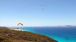
Saturday we drove the “Great Ocean Drive”, a loop drive around Pink Lake and along the coastline west of Esperance. Pink Lake wasn’t pink (the algae must have died), but the coastline was spectacular (I’ve probably overused that word, but certainly fitting here). We stopped at a number of bays, watched paragliders, walked Twilight Beach, and just enjoyed a warm, sunny day.
Great site for paragliders
In the afternoon we visited the local Cannery Arts Centre, where they had a fundraising afternoon featuring local musicians and supported by Esperance’s Lucky Bay Microbrewery. I can confirm the beer was of excellent quality.

Sunday we checked out of the caravan park and headed into town to buy groceries etc. It will be a hot day, expecting 360C, and the Esperance Christmas celebrations are on, so will be staying around town until the evening before driving north.

Saturday, December 3, 2016

Peaceful Bay to Cosy Corner

November 27 to December 4

The view across Torbay, from near our campsite
Our blog ended last Sunday morning as we left Peaceful Bay, driving about 45km to Denmark. We had read some unflattering reviews of Denmark and their “less than enthusiastic” attitude to RV’s. I have to say we found none of that, it was a very inviting little town and a very helpful Visitor Centre. They gave us some great suggestions for the day’s sightseeing, and strongly suggested we go to the free camp that night at Cosy Corner Beach, about 30km away, half way between Denmark and Albany.
Cosy Corner Beach looking East to Albany
We did a couple of walks around the river and the Karri Walk (part of the Bibbulmun Track) and had lunch in town, before heading to Cosy Corner Beach. Albany City Council have become proactive in setting up and running free camping and low cost camping options to encourage travellers to the region. They have arranged the camp area very well with toilets and allotted camp sites, of which some are very large so quite private. A council supported volunteer “Camp Host” tries to keep the site running smoothly, as there is a seven day maximum stay limit.
Our campsite behind the dunes, Cosy Corner Beach
As you can see from the photo, this is an amazing locality. Although quite isolated, you are only 30km from Albany, great phone and data service, TV reception, even decent radio reception. We arrived, planning on staying one or two nights, but soon decided to stay the maximum seven.
The wide bay that Cosy Corner Beach is part of, is partially protected by a number of granite islands, so not too much swell gets in. The Albany Wind Farm resides on the cliffs on the east side of the bay, which is also a popular area for para-gliding. That also means there was constant wind.
Although we weren’t planning on an extended stay, we had plenty of food and a full tank of water, and our camp site had excellent sun exposure for the solar panels. It was also timely to be in one spot for a period, so we could get our mail forwarded (thanks Russell and Steve). We also had some “home administration” work to complete and a trip to Albany on Thursday allowed us to complete some business as well as restock on food, water and other essentials (beer and wine).
Small trevally, or big rod?
The wind was kind on two mornings so I had the chance to do some beach fishing. A couple of small trevally and salmon were caught, but not of noteworthy size. We did a lot of beach walking and exploring along the dune area, as the Bibbulmun Track passes through the area. The weather like a Queensland winter here, averaging 200C during the days (ranging 17-24) and 100C at night. It’s an interesting observation of our travels, we “wintered” in the tropics to typical South East QLD summer temperatures, yet the lead up to summer in the south of WA has been equivalent to a QLD winter.
Flies are also in plague proportions here. Since entering Western QLD we have encountered varying levels of fly population, very thick through far west QLD and mid NT, and also very thick through the Pilbara north of Carnarvon. Now we have reached the southern coastline of WA we again find ourselves choosing not to spend a lot of leisure time sitting outside the motorhome. Fly nets covering heads are an established outdoor fashion accessory.
St. Leah, a Solar Halo or Nimbus event at Cosy Corner
I also had a chance to do some upgrades to my mountain bike. A camper turned up with a (pretty expensive) mountain bike mounted on the roof of his car, which he had trashed by driving into an underground car park. He left it in a pile at the rubbish bins when he left, another camper got some parts off it, and so I removed the tyres (way better than mine) and the gear selectors. It has made a real difference to my (way cheaper) bike.
Mitch and Courtney lookin' sharp.
Sunday we reluctantly departed Cosy Corner to head just up the road to a caravan park in Albany so we can do the usual washing and cleaning chores.
For interest, I also added a recent photo of Mitchell and partner Courtney (CJ), at the end of year ball to celebrate CJ’s completion of her Paramedics degree. They have developed into fine adults, we are very proud of them both.
A second aside, for those who may be trying to ring Leah’s dad Russell, he is having a stoush Telstra and his phone has been out of commission. Hopefully this will be rectified very shortly.

Saturday, November 26, 2016

Balingup to Peaceful Bay

November 20 to November 27
Sunday we drove to Balingup, following the Blackwood River as it meanders through some spectacular Karri and Jarrah forests. This is the heart of the timber country, and the road is hugged by 30 metre tall trees, with some plantation gum and pine areas here and there.
This Blackwood River Valley region is primarily timber and wine vineyards, and further south there is agriculture and mining added into the mix. This is also serious bushwalking and hiking country, with the Bibbulmun Track and Munda Biddi Trail (both stretching some 500+kms from near Perth to Albany, but following different routes) criss-crossing the region. There have been plenty of opportunities to walk sections of these trails throughout our travels south of Perth.
Plenty of Heritage and Historical Visits
Balingup is home to the well-known Golden Valley Tree Park, a massive botanic park where the trees of Australia and the world have been planted and walks (including a section of the Bibbulmun Track) take you through a fantastic array of varieties. We spent a couple of hours, getting a bit lost at times, walking the park.
In the afternoon we drove to Greenbushes, just 15km south, and toured their Discovery Centre. It was a very well resourced, interactive presentation of the local industries and heritage, primarily mining and timber. We then headed just out of town to the Greenbushes Pool, a spring fed swimming waterhole where you can free camp.
Diamond Tree fire lookout, some 45 metres tall
Monday we walked Greenbushes Mining Heritage Walk, a trail that takes you around the town bushland outskirts (yep, got a bit lost again) to view the old tin mining shafts and finish at the lookout of the old Cornwall Pit open cut. Greenbushes mine is still in operation, mining the primary ore for tin and lithium from their underground mine.
We drove to Bridgetown just 20km down the road to visit their Visitor Centre (which also had a great museum attached to it) and did some grocery shopping, before checking out the river where the town gets its name. Bridgetown was originally named Geegelup and was established in the 1850’s supporting grazing and wool production, then apple and orchard farms.
We drove back to Greenbushes for Monday night and stayed at their second (yep, they have two free camps sites) overnight spot at the sportsground. We headed back to Bridgetown on Tuesday to walk the river trail, a track following the Blackwood River through some very picturesque forest.
From there we drove to Manjimup, the largest town in the Southern Forest Region, stopping at the King Jarrah Tree, a 500 year old example of this majestic eucalypt. We visited the Timber and Heritage Park, where they have buildings and steam equipment displayed tracing the establishment of the timber industry and its development over the years.
Not a lot of safety associated with this risk!
A further 10km out of town we visited the Diamond Tree, one of numerous trees in the region which were used as bushfire lookouts. The tallest karri tree in the locality was selected, topped (top canopy removed) and a “ladder” added to the trunk in a spiral. A lookout was built on top, where it was manned during the bushfire season. Three of these lookout trees are open to the public to climb, ranging from 45 to 55 metres tall. I climbed some 10 metres up for a photo, I decided that was high enough. We found a great free camp for the night about a kilometre away, at an electricity sub-station on a hill well off the road.
Wednesday we visited Pemberton, and Big Brook Dam. Another fantastic hike of some 8km around the dam through the Jarrah, Karri and Marri forest. The dam is stocked with brown and rainbow trout, and marron (freshwater crayfish). On our walk we spotted a brown trout in the shallow rapids of a feeding creek, and a marron at the dam wall. Unfortunately the season for both were closed so they lived to see another day.
Pemberton Mountain Bike Park, banked downhill section
The Pemberton Visitor Centre also had a heritage museum which we visited, unfortunately much of which we have seen at other museums in the area.
We visited the second bushfire lookout tree, the Gloucester Tree, before heading back to our “sub-station” free camp.
Thursday we drove back to Pemberton, mainly so I could ride the Pemberton Mountain Bike Park, a National Competition level trail park open to the public. I rode most of the blue trails (like ski run ratings, green, blue then black in difficulty), and compared to our Caloundra trails these were MUCH more technical, I know Mitchell and his crew would love this park!
We drove further south to Northcliffe through an even denser (if that’s possible) tall timber forest, the later part of which was badly burnt out 12 months ago. Northcliffe was a very small country town with yet another heritage museum. We visited it just to make sure the displays were similar to the others we had seen. It is great to see the local’s passion for their past and their community spirit to manage and maintain the buildings and displays.
We drove another 80km south to stop overnight at a rest area 15km out of Walpole.
Giant Red Tingle Tree
Friday was chores and washing day, so we checked in early to the Coalmine Beach Caravan Park. We still had plenty of time to explore the Knoll and walk more of the Munda Biddi Trail around Nornalup Inlet. This coastline is unusual as there is a number of narrow ocean openings, protecting large inlets or lakes. The inlets are often quite shallow and the openings close off during the dry season when the feeding rivers have low flow.
On Saturday we drove to the Tree Top Walk, a spectacular 600 metre suspended walk 40 metres into the forest canopy. This forest area is unique for the Red Tingle Tree, which only grows in this 600 hectare area. The Tingle is another eucalypt (as is the Jarrah, Karri and Marri), but is interesting as the base of the truck becomes hollow as it ages, creating openings into the tree base, which can be up to 7 metres in diameter.
Irwin Inlet, Peaceful Bay. Great camp spot.
From there we drove to Peaceful Bay, a quiet bay 10km off the highway. It was a great place for lunch then a long beach walk. The daytime temperature reached 330C, the first really warm day for a couple of weeks. On the road to Peaceful Bay we found a side track leading to another inlet lake, Irwin Inlet. As you can see from the photo, these are the overnight stops we look for. We spent a very relaxing afternoon and evening there.
Sunday we headed for Denmark, our direction is now east which means we must be on our way home. Still lots more to see and do, but we’re now well more than half way around.