November 20 to November 27

This Blackwood River Valley region is primarily timber and
wine vineyards, and further south there is agriculture and mining added into
the mix. This is also serious bushwalking and hiking country, with the
Bibbulmun Track and Munda Biddi Trail (both stretching some 500+kms from near
Perth to Albany, but following different routes) criss-crossing the region.
There have been plenty of opportunities to walk sections of these trails
throughout our travels south of Perth.
 |
| Plenty of Heritage and Historical Visits |
Balingup is home to the well-known Golden Valley Tree Park, a
massive botanic park where the trees of Australia and the world have been
planted and walks (including a section of the Bibbulmun Track) take you through
a fantastic array of varieties. We spent a couple of hours, getting a bit lost
at times, walking the park.
In the afternoon we drove to Greenbushes, just 15km south,
and toured their Discovery Centre. It was a very well resourced, interactive
presentation of the local industries and heritage, primarily mining and timber.
We then headed just out of town to the Greenbushes Pool, a spring fed swimming
waterhole where you can free camp.
 |
| Diamond Tree fire lookout, some 45 metres tall |
Monday we walked Greenbushes Mining Heritage Walk, a trail
that takes you around the town bushland outskirts (yep, got a bit lost again)
to view the old tin mining shafts and finish at the lookout of the old Cornwall
Pit open cut. Greenbushes mine is still in operation, mining the primary ore
for tin and lithium from their underground mine.
We drove to Bridgetown just 20km down the road to visit
their Visitor Centre (which also had a great museum attached to it) and did
some grocery shopping, before checking out the river where the town gets its
name. Bridgetown was originally named Geegelup and was established in the
1850’s supporting grazing and wool production, then apple and orchard farms.
We drove back to Greenbushes for Monday night and stayed at
their second (yep, they have two free camps sites) overnight spot at the
sportsground. We headed back to Bridgetown on Tuesday to walk the river trail,
a track following the Blackwood River through some very picturesque forest.
From there we drove to Manjimup, the largest town in the
Southern Forest Region, stopping at the King Jarrah Tree, a 500 year old
example of this majestic eucalypt. We visited the Timber and Heritage Park, where
they have buildings and steam equipment displayed tracing the establishment of
the timber industry and its development over the years.
 |
| Not a lot of safety associated with this risk! |
A further 10km out of town we visited the Diamond Tree, one
of numerous trees in the region which were used as bushfire lookouts. The
tallest karri tree in the locality was selected, topped (top canopy removed)
and a “ladder” added to the trunk in a spiral. A lookout was built on top,
where it was manned during the bushfire season. Three of these lookout trees
are open to the public to climb, ranging from 45 to 55 metres tall. I climbed
some 10 metres up for a photo, I decided that was high enough. We found a great
free camp for the night about a kilometre away, at an electricity sub-station
on a hill well off the road.
Wednesday we visited Pemberton, and Big Brook Dam. Another
fantastic hike of some 8km around the dam through the Jarrah, Karri and Marri
forest. The dam is stocked with brown and rainbow trout, and marron (freshwater
crayfish). On our walk we spotted a brown trout in the shallow rapids of a
feeding creek, and a marron at the dam wall. Unfortunately the season for both
were closed so they lived to see another day.
 |
| Pemberton Mountain Bike Park, banked downhill section |
The Pemberton Visitor Centre also had a heritage museum
which we visited, unfortunately much of which we have seen at other museums in
the area.
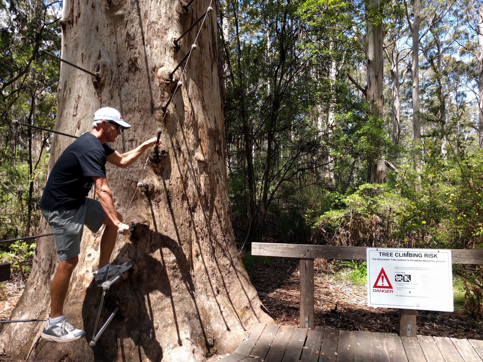
We visited the second bushfire lookout tree, the Gloucester
Tree, before heading back to our “sub-station” free camp.
Thursday we drove back to Pemberton, mainly so I could ride
the Pemberton Mountain Bike Park, a National Competition level trail park open
to the public. I rode most of the blue trails (like ski run ratings, green,
blue then black in difficulty), and compared to our Caloundra trails these were
MUCH more technical, I know Mitchell and his crew would love this park!
We drove further south to Northcliffe through an even denser
(if that’s possible) tall timber forest, the later part of which was badly
burnt out 12 months ago. Northcliffe was a very small country town with yet another
heritage museum. We visited it just to make sure the displays were similar to
the others we had seen. It is great to see the local’s passion for their past
and their community spirit to manage and maintain the buildings and displays.
We drove another 80km south to stop overnight at a rest area
15km out of Walpole.
 |
| Giant Red Tingle Tree |
Friday was chores and washing day, so we checked in early to
the Coalmine Beach Caravan Park. We still had plenty of time to explore the
Knoll and walk more of the Munda Biddi Trail around Nornalup Inlet. This
coastline is unusual as there is a number of narrow ocean openings, protecting
large inlets or lakes. The inlets are often quite shallow and the openings
close off during the dry season when the feeding rivers have low flow.
On Saturday we drove to the Tree Top Walk, a spectacular 600
metre suspended walk 40 metres into the forest canopy. This forest area is
unique for the Red Tingle Tree, which only grows in this 600 hectare area. The
Tingle is another eucalypt (as is the Jarrah, Karri and Marri), but is
interesting as the base of the truck becomes hollow as it ages, creating openings
into the tree base, which can be up to 7 metres in diameter.
 |
| Irwin Inlet, Peaceful Bay. Great camp spot. |
From there we drove to Peaceful Bay, a quiet bay 10km off
the highway. It was a great place for lunch then a long beach walk. The daytime
temperature reached 330C, the first really warm day for a couple of
weeks. On the road to Peaceful Bay we found a side track leading to another
inlet lake, Irwin Inlet. As you can see from the photo, these are the overnight
stops we look for. We spent a very relaxing afternoon and evening there.
Sunday we headed for Denmark, our direction is
now east which means we must be on our way home. Still lots more to see and do,
but we’re now well more than half way around.
No comments:
Post a Comment